of maps & mapping
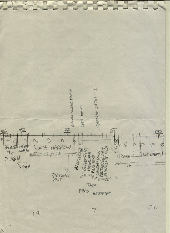
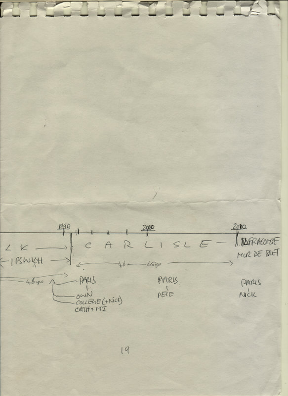
We began with the timelines
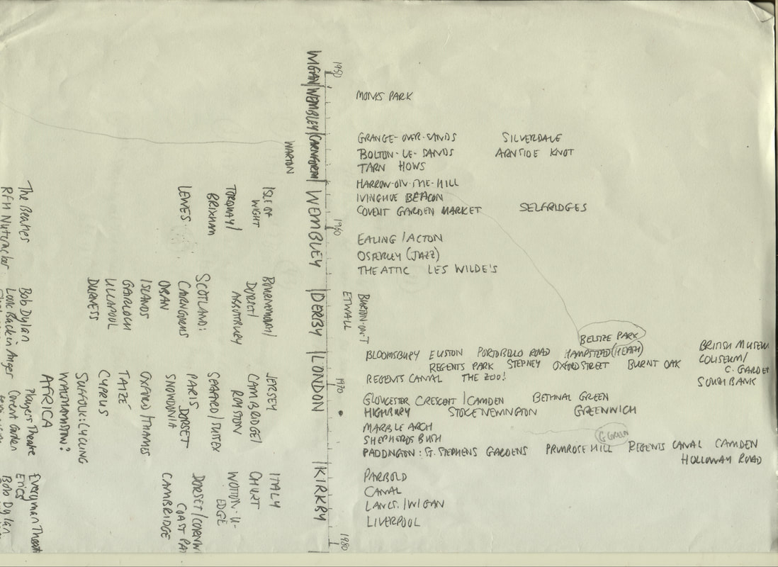
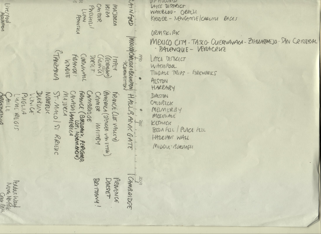
then moved to a geographical scheme:

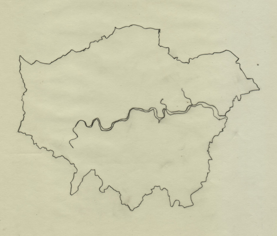
We traced outlines of areas common to both (here, Greater London & Cumbria)…
|

|
and transferred them to cardboard cut outs with a view to hanging in such a way that would illustrate the correspondences between our geographies:

|

|
We made plans of where we were and where we might go next:

|

|
We revisited the composite map in Di’s Territories project:
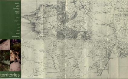
"I wanted to make more process-driven work based on the concept of personal relatedness to place. I began to make marks in places that were meaningful to me – a marking of place without leaving visible trace.
To do this, I urinated on the ground of six different locations; three in Cumbria where I lived, two in Devon where I had holidayed throughout my life, and two in Scotland where I had camped each May while living in Carlisle.
Territories map 1, therefore, depicts these locations. I used Photoshop to create a ‘map’ of my own from scanned 1:50,000 Ordnance Survey maps. The exact spots are recorded through a stencil mark on the resulting map. The front cover of this created map is made up of the photographs of these spots. The back cover of the map is a ‘key’ – a list of words describing the type of location where the marks were made.
This work related to my drawing practice – mark-making, printing, imprinting – and also references the ‘journey’ that continued to be important for me."
We took inspiration from others’ maps and made our own:
 Coleridge Lakes Notebook 1802 Coleridge Lakes Notebook 1802
|

Di's Woods Memory Map
|
“Beginning to walk alone again after I had had a stroke, I explored the little woods near to where we live. When I passed particular spots on the way, I began to name them as fanciful places such as – “witches’ coven”, “wizards’ well” or other names serving as mark-ways such as “leafy lane” or “bird song corner”.
Back home, inspired by the Samuel Coleridge Lakes Notebook 1802, I tried to remember my route and write it on paper.
After several unsuccessful attempts – I didn’t expect it to be so hard to visualize the route on paper and connect it to my hand! So after more walking the route from memory, I came up with the resulting ‘map’ on paper. My grandchildren used it to find their way to follow my route in the woods when they visited.”
"
on maps and mapping: kate
I hated geography at school and had no interest in maps. Despite a teenage conviction that one day I would see India, I wasn’t even much interested in the world beyond my window and made little use of the free train travel across Europe I earned for being a railwayman’s daughter. So it seems strange that by my mid-thirties I was desperate to get away and ironic that at the age of 37 I found myself in a classroom in Mexico City teaching international students from the same British Geography textbook I was burdened with as a child. I had a wall map of the country pinned to a cupboard door in the small house I rented on the western edge of the city. The map provided inspiration for many weekends away in the beat-up old ‘Bocho’ that belonged to my two young Canadian friends and it (map not car) was later transferred to a wall in our house in Cumbria, keeping alive the promise that I’d return to Mexico one day. I didn’t, though the map has survived, yellowing and tattered, traces of blu-tack on the corners. I unfold it gingerly, some of its sections cracking apart along the folds. I spread it out on the table and peer at the names, searching for the familiar, retracing my footprint as memories leap up at me: the hit of the exhaust-heavy air when you arrive, frosty January wakings, the tops of the volcanoes against the blue on the rare clear morning, the steamy heat of a jungle dawn, the bite of salsa on the tongue before the rush of cold beer, tamales and nopales and huitlacoche, faces and voices, the person I was, the tears I cried, the futures I imagined; a tangible link to a world that I once claimed as mine.
Like the maps of our childhood territory – Middle Earth and Narnia, the Hundred Acre Wood and the riverbank – my Mexican map represents both adventure and security. Like the maps in Coleridge’s notebooks, it’s a record, a memento of personal wanderings. Other maps have become souvenirs, too: the one that marks all the milongas in Buenos Aires, so well-used it’s on the point of disintegrating or the hundred-plus pages of maps that accompany the bus timetable for the same city, confusingly following the usual orientation of north at the top whilst most maps in Argentina point south. I was intrigued to stumble online upon a 1950s CIA surveillance map of a village I’d visited in Bulgaria, with details of each household and workplace with an assessment of their security risk. An entirely other revisioning of the map is a memorial to my friend and poet Pauline Radley which folds out like an OS map but is composed of poems about trees, with pen and ink drawings. Or there is the radical vision of Iain Sinclair, walking a ‘crude V’ in east London, ‘recording and retrieving the messages on walls, lampposts, door jambs… Railway to pub to hospital: trace the line on the map… the born-again flaneur is a stubborn creature, less interested in texture and fabric, eavesdropping on philosophical conversation pieces, than in noticing everything.’[1] Some maps take on a talismanic quality: my pocket-size A-Z still comes with me when I make it to London though who needs it when Google Maps is so comprehensive? In times when venturing far is difficult, a map is a resource for the armchair traveller, an invitation to ‘boldly go’, to head ‘to infinity and beyond’, at least in the imagination. Like a musical score, it can be a route to beauty, or a work of art in itself, such as Robert Smithson’s installation ‘Map of Broken Glass (Atlantis)’. Books about journeys are often prefaced with a map – in Patagonia, A Time of Gifts, Passage to Juneau; in others (especially fiction – Robinson Crusoe, Heart of Darkness, Huckleberry Finn) the map is implied. Maps may offer clues – as in ‘x marks the spot’ to buried treasure – though often there is a puzzle to solve, if not a deliberate attempt to send the treasure-seeker off on a false trail. There are maps for walkers that accrue in their crumpled weather-worn state the particular memory of a wind-swept fell-top, for example, along with the person who shared the day, maps for cyclists and farmers and tourists, maps of the cosmos and astrological charts. There are many alternatives to what has become the traditional two-dimensional paper projection, from song lines and ley lines to Greenland’s maps traditionally carved in stone or bone so that the terrain or coastline can be traced with the fingers inside a sealskin mitt in extreme temperatures. In The Library of Ice, Nancy Campbell describes the way sled trails & skate traces & footsteps in the snow become maps or, of Antarctic explorers: ‘the snow that they stepped on, compressed by the weight of the body, would remain fixed in place as the lighter, unmarked snow around them blew away. These pillars of ice were visible from far away long after the explorer had passed on.’
The concept of life as a journey has become all too familiar: from the wanderings of Ulysses or his latter-day alter ego Leopold Bloom to the enforced real-life migration of those forced to flee danger or deprivation, it is hard not to see ourselves as travellers in search of some goal. The poet Cavafy advises
hope your road is a long one
full of adventure, full of discovery[2]
Mary Oliver sees us as part of a world in motion:
Meanwhile the sun and the clear pebbles of the rain
are moving across the landscapes,
over the prairies and the deep trees,
the mountains and the rivers.
Meanwhile the wild geese, high in the clean blue air,
are heading home again…[3]
As we embarked on our project, we saw the correspondences in our timelines and attempted to map our memories following the paths of early cartographers, drawing our worlds according to what we knew, with ourselves at the centre. We altered coastlines and contours to reflect our own experiences, always in search of that elusive representation of our separate paths, occasionally touching, sometimes crossing, sometimes running alongside each other before veering apart again. My initial vision of a Perspex block continues to elude us but the search remains infinitely absorbing.
[1] Iain Sinclair: Lights Out for the Territory
[2] CP Cavafy: ‘Ithaca’
[3] Mary Oliver: ‘Wild Geese’